About Sagar - Introduction
Sagar, Madhya Pradesh
Sagar, formerly Saugor, is a city, municipal corporation and administrative headquarter in Sagar district of the state of Madhya Pradesh in central India.
Google Map Location
The district of Sagar lies in the north central region of Madhya Pradesh. It was spelled as Saugar during the British period.
The district of Sagar lies in the north central region of Madhya Pradesh. It was spelled as Saugar during the British period. It is situated between 23 deg 10’ and 24 deg 27’ north latitude and between 78 deg 4’ and 79 deg 21’ east longitude, the district has a truly central location in the country. The tropic of cancer passes through the southern part of the district.
- Sagar has been selected as one of the hundred Indian cities to be developed as a smart city under Prime Minister Narendra Modi's flagship Smart Cities Mission.
- Dr. Hari Singh Gour Vishwavidyalaya is the oldest University of Madhya Pradesh situated in Sagar city. It was established in 18 July1946 by Sir Harisingh Gaur, in 15 January 2008 it got the status of Central University.
- Sagar is also very famous for the Mahar Regiment of the Army, the headquarters of this regiment is located here. Jawaharlal Nehru Police Academy is also located here. Head quarter of Forensic Science Lab is also in sagar.
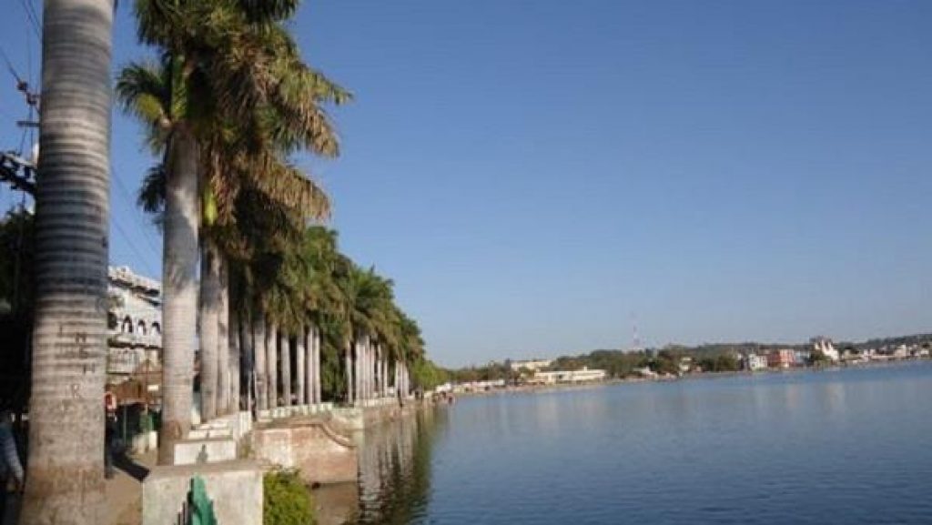
The origin of the name comes from the Hindi word SAGAR meaning lake or sea, apparently because of the large and once beautiful lake around which the town of Sagar has been built. Sagar was founded by Udan Singh in 1660 and was constituted a municipality in 1867. A major road and agricultural trade centre, it has industries such as oil and flour milling, saw-milling , ghee processing , handloom cotton weaving, bidi manufacture and railway and engineering works.
The town of Sagar serves as its administrative center. Sagar district is called the heart district of India. Tropic of Cancer (23°3') passes through Rangir Tiraha on NH26 present NH44 in Sagar district.
Sagar, Madhya Pradesh
History
The history of the town of Sagar dates back to about 1660 A.D. When Udan Shah, a descendant of Nihal Shah, built a small fort on the site of the present one, and founded a village close to it called Parkota which is now part of town. The present fort and a settlement under its walls was founded by Govind Rao Pandit, an officer of the Peshwa, who held charge of Sagar and the surrounding territory after 1735 A.D., when it came under the Peshwa’s possession.
In 1818 A.D., the greater part of the district was ceded by the Peshwa Baji Rao II to the British Government, while different parts of the rest of the present district of Sagar came in the possession of the British at different times between 1818 and 1860. The Dhamoni pargana of Banda tahsil was ceded in 1818 A.D. by Appaji Bhonsla. The Bhera pargana of Banda tahsil was acquired by transfer from the Bundelkhand States in 1818 A.D. The parganas, Rahatgarh in Sagar tahsil and Garhakota, Deori, Gourjhamer and Naharmow in Rehli tahsil collectively known as Punch Mahal were originally made over to British by Sindhiya at different dates from 1820 to 1825 for management. The Shahgarh pargana of Banda tahsil was confiscated in 1857 in consequence of the rebellion of the chief. The Kanjia pargana of Khurai tahsil was acquired from Sindhia by a treaty in 1860 A.D. A small area in the north -east corner of the tahsil around the village of Hirapur was similarly transferred to the British from the Charkhari State to Bundelkhand and added to the district after the uprising of 1857.
Administratively, the position of Sagar and the neighbouring territories underwent frequent changes. The Saugor territory was, first of all, placed under the superintendent of Political Affairs of Bundelkhand. Later, in 1820, this area, called the Saugor and Nerbudda Territories, was placed under the administration of an Agent to the governer-General. When the North-Western Province was constituted in 1835, the Saugor and Nerbudda Territories were included in this province. In 1842 occurred the Bundela rising, the quelling of which demanded a more direct attention by the Governor-General. But order was restored in the following year, and the Saugor and Nerbudda Territories were again placed under the political control of an Agent to the Governor-General. The arrangement however, was not found to be satisfactory and these territories were once again restored to the North-Western Provinces in 1853. Thereafter in 1861 the Saugor and Nerbudda territories, along with the Nagpur state formed a Commissioner’s Province called Central Provinces.
Sagar, which was the headquarters of the Sagar Commissionership for a short period, ceased to be so in 1863-64, when this district was incorporated with Jabalpur Commissionership. In the year 1932 the district of Damoh was added to Sagar district and was administrated as Sub-Division. In 1956, however, Damoh Sub-Division was again separated from the district to form a separate district and Sagar district consisted of four tehsils viz, Sagar, Khurai, Rehli, Banda.
Geography & Climate
Sagar city is situated on a spur of the Vindhya Range, 1,758 feet (536 m) above sea-level around 172 kilometres (107 mi) northeast of the state capital, Bhopal.
Sagar has humid subtropical climate with hot summers, a somewhat cooler monsoon season and cool winters. Very heavy rainfalls in the monsoon season from June to September.
Demographics
- Area: 10,252 Sq. Km.
- Population:2,378,458
- Male:1256257
- Female:1122201
- Language:Hindi, Bundelkhandi
- Villages:1902
Government
Sagar city is part of Sagar assembly constituency, Shailendra Jain is the MLA from here, He is from Bhartiy Janta Party.
Sagar contributes one member to the Lok Sabha. The entire Sagar Assembly is part of the Sagar Lok Sabha, Smt. Lata Wankhede Is an MP from Sagar, Bharatiya Janata Party had been elected as the Member of Parliament in the 2024 Lok Sabha election.
Smt. Sangeeta Sushil Tiwari elected mayor of Sagar Municipal Corporation in the 2022 Sagar Mayor election, she is also from Bhartiy Janta Party.
Industry
With many proposed large and small scale industries, the economy of Sagar is bound to grow at a fast pace. It is also a major hub for useful minerals.
The stainless steel complex is also in Sagar. The lakha banjara lake in the centre of the city provides a wonderful panorama. Dr. Hari Singh Gour central university First and one of the oldest universities of Madhya Pradesh established in 1946 is in Sagar. Due to its scenic beauty and proximity to Khajuraho tourism also contributes to strengthening its economy. In Madhya Pradesh, Sagar is the sixteenth largest district in size.
These small scale industries mainly manufacture steel utensils, detergent cake, and powder, agricultural equipment, Agro Fertilizers, food processing, cattle feed, Laminated Glass, welding electrodes, plastic goods, alum, caustic soda, solvent plant, granitbillie stone, pipes, acrylic sheets, PVC cable, acrylic products, incense sticks, all-purpose flour, etc. Beedi (A traditional Tobacco used in India) and Agarbatti making is one of major small manufacturing industry in Sagar.
The north-south corridor passes through Sagar city, hence the hotel industry here has also made considerable progress. Many large educational institutions are located here which make it a center of education. Which makes a huge contribution to the economy of Sagar.Many shopping malls and complexes are also located in Sagar.
Industrial Area
- Siddhguwan Industrial Area
- Mega Industrial Park Sagar
Tourism
Sagar has a noatble tourist places.
Tourist Places
- Gadpehra Temple
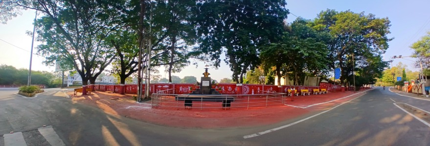
- Harsiddhi Devi Mandir, Rangir
- Khimlasa
- Nauradehi Wildlife Sanctuary
- Rahatgarh Water Fall
- Sagar lake
- Aabchand Caves
- Mandi Bamora
Places of Interest
Abchand , Tehsil Sagar - In the ravines of river Gadheri,ensconced in the dense growth of Abchand reserve forest ( 23 45′ N and 78 55′ E), about 22 miles east of Sagar on the Sagar-Damoh road, exist about a dozen rock-cut caves with paintings of the same type as found at Singhanpur and Adamgarh.The largest cave is about 40 feet in length and its walls contain more than a dozen paintings showing activities of the pre-historic men.The hunting scenes represent individual or group of hunters. They are equipped with bows and arrows, spears and other weapons. The game animals shown in these paintings,are bison’s, bulls,deer antelopes, tiger, boars etc. In one of the Shelters a fierce fight between two tigers is fitfully depicted.The primitive people seem to have amused themselves with songs and dances. At one place seven figures are shown dancing hand-in- hand in a row. In front of them are played instruments like drums, dhapli and flutes. The colours used in these paintings are yellow, green, red, black, and white. The red colour shows different shades, dark orche and pink. The super- imposition or overlapping is also clear in some cases. There are alos some symbolic representations such as the swastikia, taurine, cross and the tree within railing symbols.
Baleh, Tehsil Rehli - Baleh Tehsil Rehli Situated in 23 degree 35 N and 79 degree 10 E it is a village 36 miles south-east of Sagar and 11 miles from Rehli with which it is connected by a road. A record found here mention Palvana or Yalavana Pattala and refers to a Chandika temple. Formerly the estate of Baleh consisting of 53 villages belong to a gond family of Patehra, which being driven out of Deori, settled here in 1747. It has some old tanks and betel vine gardens producing a leaf of some reputation.
Bamora, Tehsil Khurai - Bamora, Tehsil Khurai – A large village, lying 23 degree 35’N and 79 degree 05’E is a railway station on the Bina-Itarsi line of the Central Railway. There is a ruined temple built of stone without mortar similar to the one at Janjgir. The date of erection is not known, but it is believed to be very ancient. It contains a small stone image of a Varaha and one of a horse with rider. In one corner is an image of Shiva placed there since the temple passed out of its original use. There are also Buddhist ruins in the village.
Barodia kalan, Tehsil Khurai - Barodia Kalan, Tehsil Khurai Situated in 24 degree 10′ N and 78 degree 35′ E, it is 30 miles north of Sagar on the Jhansi road. There is a ruined fort of the late mediaeval period in the village. On 31 January 1858, an encounter took place at Barodia Kalan between a British force and the insurgents, who had concentrated here after the fall of Rahatgarh fort. A remarkable scene of heroism was enacted in this place, as the Afghan soldiers, even when dying, killed their enemies with their broad swords. From the river Bina to the garhi the British had to fight their way step by step. The fort was surrounded and occupied, but the casualties suffered by the victors were severe.
Gadpahra, Tehsil Sagar - This is also called old Sagar,was the capital of the Dangi Kingdom. It is situated six miles north of Sagar on Jhansi road. Gadphara still has some historical remains. The fort build on a low range of hills, is approached by a steep road leading to bastion, a rough gateway and a white washed temple on a platform. There are remains of a summer residence called a Shish Mahal or Glass palace of the Dangi Rular. It is a square building very much like a Muslim tomb consisting of two stores, each room having a veranda all around. The glassed tiles of various colors are fixed alternatively in the panel of the battlement and in the ribbing of the domes. It is attributed to Raja Jaisingh who is supposed to have live about 200 years ago. In the neighbour hood is a tomb which is treated as an object of worship.Below the hill toward the north is small lake called Motital.
Eran, Tehsil Khurai - An ancient site lying at the junction of Bina and Reuta rivers, 6 miles from Bamora station on the central railways. By its natural situation, Eran is at the gate of Bundelkhand on one side and Malwa at the other. The name is derived from the abundant growth of ERAKA, a sort of grass of emollient and diligent properties. The village of Eran has a most interesting collection of archaeological relics. There is a fort in rulings attributed to the Dangis, who formerly dominated over this region. The site had a number of Vishnu shrines but nothing now remains except some of the lower courses of masonry, four standing columns with there architrave and some beams and part of door ways. The Principal statue is a colossal Varaha about 10 feet high. The excavation conducted by the Department of Archeaology of the University of Sagar have yielded relics similar to those found at Maheshwar and Tripuri showing that Eran formed the Northern most limit of the Chalcolithic culture in Madhya Pradesh.
Rangir, Tehsil Rehli - A village situated 10 miles from Rehli and 21 miles from Sagar on Sagar Rehli Road on the bank of the Dahar river. It was site of an engagement between Chatrasak Bundela and Khaliq, the Mugal Fauzdar of Damoni. On the adjoining Hill stands a temple of Harsiddi Devi in whose honour fairs are held in the months of Asvina and Chaitra. The Chaitra fair is an important one and large number of people visit the temple. The image of the goddess is held in great veneration and people believe that she changes her form thrice every day , as a child at dawn, a young girl at mid day and a old women in the evening. A government rest house of forest department is located here.